THE CLUB HOLDS REGULAR MEETINGS AND FIELD TRIPS.
NEW MEMBERS AND VISITORS ARE VERY WELCOME
Events in July 2026
| MonMonday | TueTuesday | WedWednesday | ThuThursday | FriFriday | SatSaturday | SunSunday |
|---|---|---|---|---|---|---|
29 June 2026
|
30 June 2026
|
1 July 2026
|
2 July 2026
|
3 July 2026
|
4 July 2026
|
5 July 2026
|
6 July 2026
|
7 July 2026
|
8 July 2026
|
9 July 2026
|
10 July 2026
|
11 July 2026
|
12 July 2026
|
13 July 2026
|
14 July 2026
|
15 July 2026
|
16 July 2026
|
17 July 2026
|
18 July 2026
|
19 July 2026
|
20 July 2026
|
21 July 2026
|
22 July 2026
|
23 July 2026
|
24 July 2026
|
25 July 2026
|
26 July 2026
|
27 July 2026
|
28 July 2026
|
29 July 2026
|
30 July 2026
|
31 July 2026
|
1 August 2026
|
2 August 2026
|
Chairman – Andy Powell (elocchairman@gmail.com)
Secretary – Adrienne Lancaster (elocsecretary@gmail.com)
Treasurer – Peter Baldwin (peter_aileen@hotmail.com)
Recorder – Ian Lancaster (elocrecorder@gmail.com)
Speaker’s Secretary – Christine Leeming (Leemingcm@outlook.com)
To apply for membership or for further information, please contact the Club Secretary.
Membership Costs £15 pa.
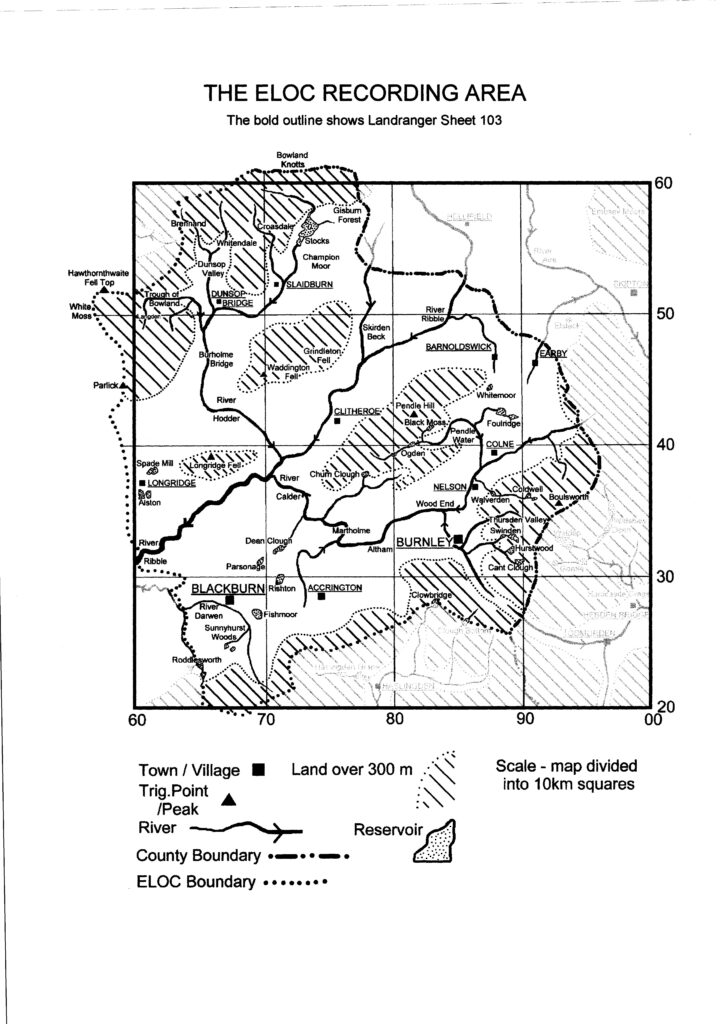
ELOC Recording Area
The recording area consists of the whole of the Burnley, Hyndburn, Pendle and Ribble Valley Districts and Blackburn with Darwen except for the southern end (Turton / Entwistle area) which lies in the Irwell catchment. Perhaps the simplest guide to the club’s recording area is that its perimeter mainly follows watersheds except where it cuts across the River Ribble. The area thus includes the catchment of the Ribble (from Alston and Balderstone in the SW up to the North Yorkshire boundary between Paythorne and Hellifield in the N), the complete catchments of the Hodder and Calder and the Darwen catchment above Samlesbury Bottoms.
In order to provide a comprehensive service for local and visiting birders, records are also welcome from anywhere in ‘Greater’ East Lancashire, i.e. the recording area as outlined above plus all parts of the county that lie south of the River Brock and east of the M6 and M61. This additional area thus includes small areas of the Preston, South Ribble and Chorley Districts, southern parts of Blackburn with Darwen and Rossendale. Birds do not respect administrative boundaries and so we are also happy to receive records from any sites in North Yorkshire that lie within c.8km (5 miles) of the current Lancashire/Yorkshire boundary. (There is no need to accept records from adjacent parts of West Yorkshire because they are already covered by the Bradford and Calderdale clubs, with records published on their own websites.) Records received from any of these additional areas are passed to the appropriate recorders at the year end.
Most of the recording area can be found on Ordnance Survey Landranger Map 103 (Blackburn and Burnley).
Other OS maps needed are:-
98 (Wensleydale and Upper Wharfedale) – northern edge of the Ribble Valley District and adjacent parts of North Yorkshire.
102 (Preston and Blackpool) – western portion of the Ribble Valley District and eastern portions of the Preston and South Ribble Districts.
109 (Manchester) – southern portions of Blackburn with Darwen and Rossendale Districts and the eastern portion of the Chorley District.